|
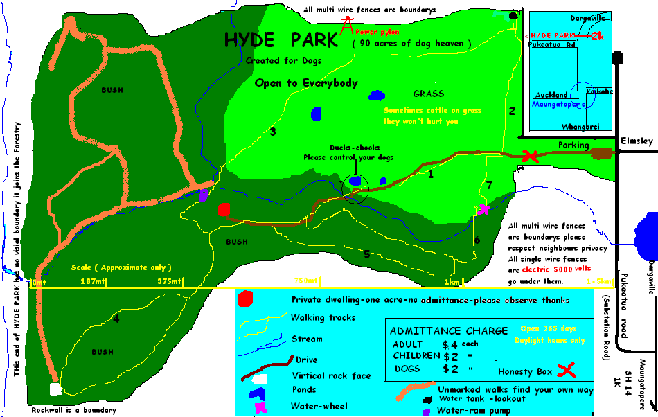
HYDE PARK at 227 PUKEATUA ROAD MAUNGATAPERE
is the place to unwind and relax in unique and beautiful natural surroundings
WALKING TRACKS/TRAILS
- 1 Main Access : leads to all other trails - has duck pond where the ducks and hens can be fed. Also provides access for the owners to get to their house, the one-acre around the house is private and no admittance allowed.
- 2 Water Tank Lookout : this is a walk through the open spaces over grass and gives the best views of Maungatapere and Maunu extinct volcanoes. It is also a watershed ridge where the rainwater on one side of the tank flows into the Tasman Sea via the Kaipara Harbour and the rainwater on the other side of the tank flows into the Pacific Ocean via the Whangarei Harbour. This watershed ridge goes up to the top of Maungatapere Volcano then back down to the start of Pukeatua Road, along SH14 through Maungatapere town up to the top of Maunu Volcano then north-east through Western Hills.
- 3 Water Ram Loop : this trail is actually part of the historical Maori trail that the local Maori Tribes used to get from the Whangarei Harbour to the Kaipara Harbour and visa versa before there were any roads. They would follow the stream up from the Whangarei Harbour and cross the watershed ridge just below the water tank and follow the stream on that side down to the Kaipara Harbour. There is an ancient Maori Pa in the pine trees about 1km towards the Kaipara Harbour, it is thought that this Pa controlled the movements through this important area.It is a pleasant walk from the Water Tank through the grass paddocks to the bush and the Water Ram Pump then back to trail 1 or 4 . The Ram Pump supplies more than enough drinking water for one dwelling and stock on ten acres.
- 4 Rock Cliff : this is one of the most popular trails it is an easy walk through lovely mature native bush and has some very large ancient rocks. Also the Rock Cliff is the end of a lava flow from the Maungatapere Volcano thousands of years ago. At the top of the Rock Cliff is an ancient large Puriri tree estimated to be more than 500yrs old, it is 6mt in circumference . The trail then loops back onto itself.
- 5 Rocky Trail : is a delightful walk through mature Totara bush that abounds with rocks covered in moss and lichens that havent been disturbed since the Maungatapere Volcano threw them there thousands of years ago. Native birds, pigeon, tui, fantail etc can readily be seen on this trail which is a loop and comes back to the main access trail.
- 6 Water Wheel Loop : this short trail winds down to a lovely stony bottom stream and on to the Water Wheel which is only a short walk back to the car park. It is a popular return journey instead of going back up the main access trail.
- 7 Water Wheel : this water wheel is an excellent example of sustainable energy use it has been here for over 30 years and has been rebuilt several times.It uses the polluted stream water to pump fresh spring drinking water up to the water tank on watershed ridge which then gravity feeds 5 houses and troughs for stock on 60 acres.
P.O. BOX 97 MAUNGATAPERE 0152
EMAIL bill@hydepark.co.nz
|